The Best Walks in South Devon
Explore coast and countryside
Discover the stunning Devon coast and countryside on foot while staying at Carswell Holidays. We offer a fantastic walking holiday experience.
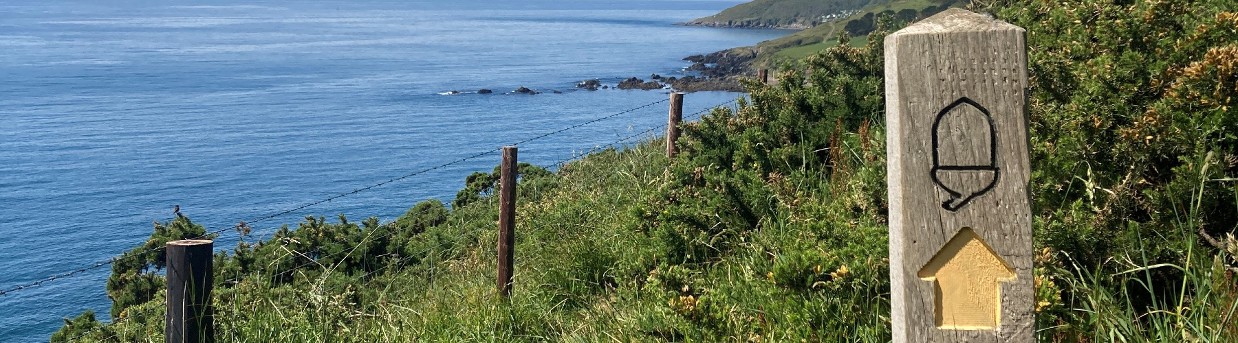
The South West Coast Path offers plenty of tremendous walks not far from your cottage, making it the perfect walking holiday destination. While Dartmoor National Park is home to fantastic views and spectacular rural scenery. Children and dogs are in heaven here, either on the vast expanses of sand at Mothecombe, on the coast path or on the wide open spaces of Dartmoor.
There are too many good walks to mention, many of which start right at your front door. Use an OS map to make best use of local foot paths and bridleways.
In case you do need inspiration, below are some of our favourites. The information is a guide only.
This is not a circular walk so you will either have to drop a car at the car park in Mothecombe (PL8 1LB) or come back along the coast path the way you came. It is a beautiful walk none the less and not too long if you just feel like striding out! It’s also relatively easy once you’re on the coastal path but there are no watering holes along the way so make sure you bring a drink. However, there is an excellent restaurant above Mothecombe Beach, The Schoolhouse, so be sure to check it out if you fancy a hot drink or spot of lunch.
Terrain: Coastal path and beach. Several stiles. One steep hill with steps. Not suitable for push chairs.
Best Time of the Year: Any.

From: Carswell (The Beach Hut)
Distance: 2 miles
Duration: 1 hour
Join the South West Coast Path. Turn right so that you are walking East with the sea on your right, passing St Anchorite’s Rock. Keep going along the path, hugging the coast for most of the walk, until you reach a sandy beach – this is Mothecombe!
From: Lambside
Distance: 3.5 miles from Lambside.
Duration: 2 hours from Lambside.
Join the South West Coast Path by walking up to the top road via the right hand side of the loop road and turning left along the top road until you see a track on the opposite side of the road. Hop over the stile if the gate is closed, and follow the track until you come to the South West Coast Path.
Turn left so that you are walking East with the sea on your right. Keep going along the path, hugging the coast for most of the walk, until you reach a sandy beach – this is Mothecombe!
Once you reach Mothecombe, you have two choices. If the tide is out you can walk over the rocks round the next headland and walk up the ramp in front of the coastguard cottages. If the tide is in you will have to take the foot path at the far corner of the beach which will bring you out in to the beach road. Turn left here and you will then see the car park on your right next to The schoolhouse.
This is the other coastal walk near by and you can do as much or as little of it as you like. We have outlined the whole walk with options to peel off if you feel like it. Much of this section of the path was made in Georgian times by Edward Baring of Barings Bank to allow his wife and ten children to travel by carriage round the coast to church at Noss Mayo. For this reason part of the path is suitable for push chairs and wheel chairs. If you’ve got wheels in tow, we suggest you drive to The Warren, park there and start your walk from here.
If you’re foot loose and fancy free you can start from your cottage and do the whole circular walk with refreshments at The Ship or The Swan in Noss Mayo!
Terrain: Moderately flat. Steeper down hill towards the end. Sturdy push chairs and adventurous wheelchairs (from the Warren Car Park only).
Best Time of the Year: Any.

From Carswell (The Beach Hut)
Distance: 8 miles (11 – 13 miles if doing the round trip)
Duration: 2 – 4 hours one way, 5 – 7 hours round trip
Join the South West Coast Path and turn left, heading West. Continue for about 1 mile until you reach the ruins of the Tea House, then follow the instructions below.
From Lambside
Distance: 6 miles (11 miles if doing the round trip)
Duration: 2 – 4 hours one way, 5 – 7 hours round trip
Join the South West Coast Path by walking up to the top road via the right hand side of the loop road and turning right along the top road. Almost immediately you will see a stile on the other side of the road, opposite Eastern Lodge. Hop over and along path by the side of the hedge. Then branch off to the left towards the ruins of the Tea House and join the South West Coast Path there. Follow the instructions below.
From the Tea House
Gather your breath here for a moment and soak in the view! The ‘Tea House’ was built by Edward Baring and was known as a ‘pleasure house’. Mrs Baring is said to have used it to take tea and paint water colours.
The next place you come to when you continue along the coast path is Stoke where there is a caravan park. Try to ignore this but, if you fancy a detour, leave the coast path and walk down toward the caravans for a peek inside St Peter’s Church. It’s a church with no roof and is virtually a ruin but still has a font and is used for a service at the beginning of the Yealm regatta week in July.
Return to the coastal path and continue on along the path going west.
A few miles later you will reach a path, which leads to Warren Car Park – this is where you will meet the coast path again on your return.
Keep going along the coastal path for another mile or so and you will be rewarded with a spectacular view, past the Mew stone and right over the Plymouth Sound. The path begins to descend through some woods. If you feel like a swim at this point (not with a push chair), take the path off to the left, just after these trees down to Cellars Beach. It’s a bit of a climb back up again though so make sure you are feeling strong. If you decide against this, the path takes you on past the old coastguard cottages, down through the woods (which are particularly impressive during the rhododendron season in early spring) and out by the back of the Ship Inn where you can reward yourself with a pint and delicious lunch!!
For those walking back, leave Noss Mayo by the road past the church hall, past the tennis courts and Brookings Wood (on your left). Keep following this lane (which eventually turns into a track) for about a mile, past a house or two until you come to the road. Turn left and then almost immediately right and you are at the Warren carpark – go through here and re-join the coast path, turning east (sea on your right) and back to your cottage.
A circular walk from Wonwell Beach (PL8 1LD) along the South West Coast Path and back inland through Kingston.
This is a lovely circular walk which starts at Wonwell Beach on the other side of the River Erme. Unfortunately to drive there you need to go all the way round the river – about an 8 mile drive. You can cross the Erme at Mothecombe for around 1 hour either side of low tide but this is unlikely to allow you time to do the walk. When driving, we advise you get there early during holiday season as parking is just at the side of the road and is not always easy in summer.

Distance: 6 miles
Duration: 3 hours (but allow extra time to relax on Westcombe Beach
Terrain: Coast path, moderate hills. Not suitable for push chairs.
Best Time of the Year: Any, but May for Bluebells.
From your car by Wonwell Beach, follow the South West Coast Path towards the sea and follow it as it climbs along the cliff edge. After rounding the headland you come to Fernycombe Point, then a couple of miles later you will come to a very steep hill down to Westcombe beach.
This is a lovely beach, only accessible by foot, so usually pretty empty. If it is low tide and you have a chance to explore, there are a lot of caves here. Just turn to the far right of the beach (as you look at the sea) and walk through an opening in the rocks to a second beach. The caves are at the far end of that beach. They are said to have been used by smugglers to store their contraband – so look out for brandy!
Once you have explored Westcombe, go back to the river and follow the path heading inland (the river should be on your RIGHT). After about 1 mile you will see a footpath and bridleway sign; take the right fork and follow the footpath for about a mile past the water works and into Kingston Village.
You can stop for a sharpener at the lovely Dolphin Pub in the centre of the village. When you are revived turn left out of the pub, left again then right still along tarmac roads. Look out for a single maritime pine tree on the corner. You can see this tree for miles around and it is known locally as the ‘Lonesome Pine’. (Keep your eyes on the horizon when you are driving along the road to Holbeton on your way home and see if you can spot it!) Continue along the made up road until you see the foot path again off to the left. Cross pretty fields and then through a wonderful bluebell wood which will bring you back to Wonwell beach.
A day trip from Plymouth Cremyll Foot Ferry to Mount Edgcumbe, round to Kingsand and back via the Cawsand Ferry. Mount Edgcumbe House and Country Park is a historic property, open during the summer months only, situated in beautiful landscape beside the sea.
This is a day’s outing really, so it’s best to start early and take it slowly as there is plenty to see including stunning views over the Plymouth Sound and Drake’s Island.
Ferry timetables can be found on the websites above, but we would recommend you call in advance to confirm operating times –
Cremyl Ferry: 01752 822105, Cawsand Ferry: 01752 253153

Distance: 4 – 5 miles (walking)
Duration: All day
Terrain: Moderately flat. Some gentle hills towards the end. No Pushchairs beyond Mount Edgcumbe.
Best Time of the Year: Easter to end of October only.
Drive to Plymouth and park in the Strand Street car park (PL1 3RL) near the Cremyll Ferry at Stonehouse. In order to find this, drive into Plymouth on the A379 and follow the signs to Torpoint. As you go on through the town you will come to a junction where there is a massive Toys R Us. Continue along Union Street, and go straight over the first roundabout you come to and then turn left at the second roundabout (just after Lidl), following signs to the Royal William Yard and the Cremyll Ferry. Follow this road for 500m then turn right onto Pound Street then right again onto Cremyll Street. Follow the signs for Cremyll Ferry parking, turning left and left again.
The Cremyll ferry runs every half hour or so, so if you find you’ve just missed one, you can grab a cup of tea and a bacon sandwich at the café at the top of the ramp.
After an 8 minute boat ride you will arrive at Mount Edgcumbe. Once here, take time to wander through the formal gardens. We don’t usually go in the house as the landscape is the main attraction, but if you choose to, you might have to sacrifice the rest of the circuit as the last ferry back from Cawsand to Plymouth is around 5pm.
Once you have explored the gardens, head down through the deer pack towards the South West Coast Path which follows the line of the river heading out to sea. You will come across various little follies along the way as well as a Napoleonic fort (now luxury apartments) at Picklecombe Point. The path eventually brings you out at the top of Kingsand, where you will have to wind your way through the narrow streets to find one of the small pubs and cafes for some refreshment. Try to take time to wander round the village as it has some special landmarks – Nelson is said to have romanced with Lady Hamilton at the Old Ship Inn in Cawsand. Look out for the old county boundary line too, which runs through one of the houses on the left as you walk the road between Kingsand and Cawsand.
Once you’ve refreshed and had a look round, you will need to walk to Cawsand Beach. This is where the Ferry runs from, usually the last ferry is around 5pm – don’t miss it or you will have to walk back the way you came! The boat comes onto the beach and you walk up a gang-plank on to the ferry. The ferry ride takes about 30 minutes, you may even see dolphins in summer!
When you get back to Plymouth, you will be dropped at the Mayflower steps, so your walk has not ended yet. The direct route back to your car is around 30 minutes walk, but we would recommend taking the scenic route along Plymouth’s magnificent Hoe. When you disembark the ferry, walk in the direction of the sea and follow the road all the way round the coast, passing Smeaton’s Tower (a 72 foot Eddystone lighthouse) and Tinside Lido, a pretty outdoor pool. Follow this road along by the water, curving round to the right then turning left at the roundabout to join Millbay Road. Take the second exit at the next roundabout to stay on Millbay Road (otherwise you will find yourself at the Brittany Ferries terminal) then turn left at the end of the road and you will find yourself back on the road you drove along to reach the car park.
If you’re too tired and hungry to go home and want to eat in Plymouth, there are plenty of cafes and restaurants to choose from. We would recommend heading back towards your car then walking further onwards to the Royal William Yard, where you will plenty of fantastic options.
This coastal walk takes in some of South Devon’s most beautiful and popular beaches – Bantham, Thurlestone, South Milton and Hope Cove.
Start your walk in Bantham, overlooking the iconic Burgh Island, and follow the South West Coast Path all the way to Hope Cove. You will have to return via the same route as far as Thurlestone Golf Club, where you can either walk back along the coast path taking in the views towards Plymouth (and Carswell!) or take an inland route through the pretty village.
There are plenty of options along the way for food and drink, and those looking for a shorter walk can turn back at any time or park along the way.

Distance: 7 miles
Duration: 2.5 hours
Terrain: Coastal path with some steep hills as well as some road.
Best Time of the Year: All year round (but be prepared for muddy paths in winter).
Drive to Bantham and park in the beach car park (TQ7 3AN). The car park is open all day but the gate is locked overnight so ensure you check what time this will be when you arrive.
Bantham is a huge sandy beach at low tide, so you might wish to spend a bit of time on the beach prior to starting your walk. Head towards the Surf Lifesaving Club which is at the southern end of the beach (the opposite end to the river mouth) and walk through the gate into the field. Follow the coast path around the edge of the field and up the steep hill, where you will find another gate at the top. Follow the coast path for around half an hour and you will reach Yarmer Beach, a beautiful stretch of sand which is great for swimming and rockpooling. Continue along the coast path which runs alongside Thurlestone Golf Course, and you will find Leas Foot Beach just around the next headland. There are public toilets here if needed, just the other side of the golf club beach.
Just the other side of the next headland is South Milton Sands, recognisable by Thurlestone Rock which is just off shore part way down the beach. You can either choose to walk along the beach (although at certain times of year you may be cut off by a stream running across the beach) or you can continue along the coast path, walking over the wooden bridge before arriving in the beach car park. Here you will find the Beach House, a great (but usually very busy!) option for a drink and a snack.
Once you are feeling refreshed, continue along the South West Coast Path which you reach by walking a short distance along the road at the southern end of the beach then turning right when you see signs. Around 20 minutes later, you will reach Hope Cove. The first small cove you arrive at is Outer Hope, where you will find the Hope & Anchor and The Cove, both an excellent lunch spot. Wander through the village and you will reach Inner Hope, a slightly larger beach (at low tide) which is protected by a breakwater.
When you are adequately rested and refreshed, retrace your steps along the South West Coast Path, passing South Milton Sands. When you reach Leas Foot Beach in front of Thurlestone Golf Club (where there are toilets), leave the coast path and walk towards the road. When you reach the road, turn left and walk up the small hill towards Thurlestone village. Walk past the post office, Thurlestone Hotel and the Village Inn.
Around 300m further along the road you will reach a junction on the left signposted towards Bantham. Follow this road just over 100m, passing a residential road on your right then turning left through a gateway with a signpost towards the coast path.
Walk through the first field, keeping near the hedgeline on your left, then as you go through a gateway into a second field, start heading downhill by turning slightly to your right. You will reach a track (which may be muddy so take care) which you follow all the way down the hill and round to the right. Once you have passed through a gateway or climbed over the stile, follow the track round to the left and continue for 100m until you reach a path on your right which goes up through trees. Follow this track and you will come out at the bottom of The Sloop Inn’s car park. This pub is the perfect place to reward yourself with a drink, or you can turn left and follow the road to the beach car park where you will find The Gastrobus and other food trucks (open seasonally).
Walk around Ugborough Beacon via a rough and scenic route.
There are lots of lovely walks on Dartmoor but this one is a relatively short one and will give you a taste of Dartmoor as well as a spectacular view of where you’ve just come from!
Distance: 3 miles
Duration: 1.5 hours
Terrain: Moorland, fairly easy walking, boots may be needed in winter. No Pushchairs.
Best Time of the Year: Any

Drive to the A38 via Ermington and Ugborough and turn as if you are going to go onto the motorway towards Exeter. Just off the slip road, before you hit the dual carriageway is a road off to the left. Take this and wiggle your way round Cheston so that you are on the road to Owley. Just before you reach Owley you will find a gate onto the moor (near TQ10 9HL) where there is enough room for several cars to park. Leave your car here and stride out taking the path straight ahead of you. The path gently rises and, if you keep following it as it curves gently round to the left, eventually you will find yourself at the top of Ugborough Beacon, demarcated by a pile of large rocks. From here you should have spectacular views of Paignton and the other way to Plymouth. When you feel you need to come down for air, continue on your way, still following a rough path, which eventually curves round back alongside an old stone wall which runs up to the gate and your car.
Walking Holiday
Take a look at our collection of holiday cottages, positioned across our hidden part of the coastline. We also have a very unique glamping experience, overlooking the coast.